|
3DVisA Resources
3DVisA Index of 3D Projects: Urban Studies | Sculpture
The Bilotti Open Air Museum: Cosenza MAB Sculpture Trail
Keywords: MAB, Bilotti, Cosenza, open air museum, 20thc sculpture, 3D, Virtual Reality, laser scanning, stereo visualisation.
The virtual Cosenza MAB Sculpture Trail was created as a new tool for urban
management and planning. It employs Augmented
Reality and a 3D city model with smart objects.
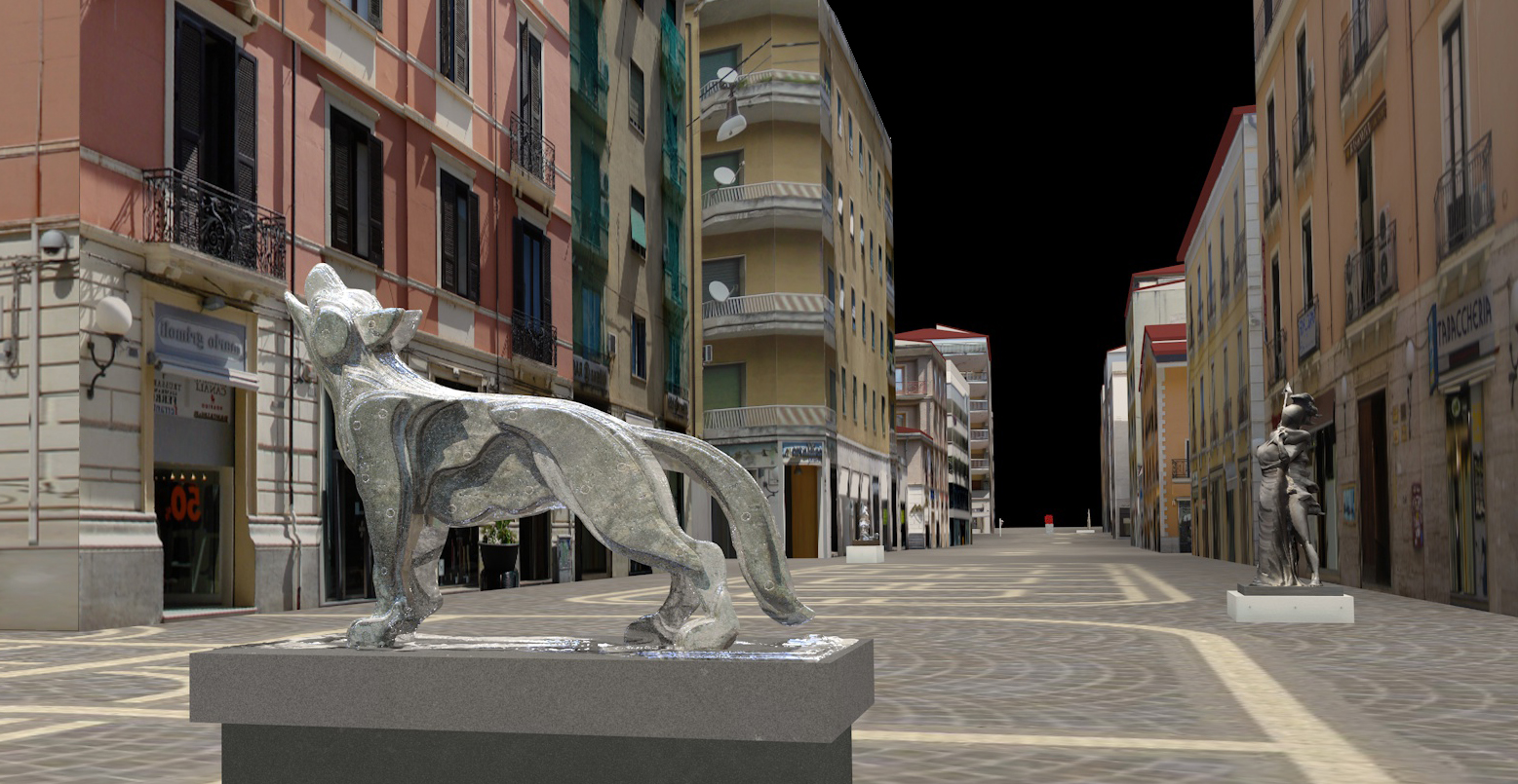
Fig. 1. View of the computer model of Cosenza with the virtual sculptures of Wolf of Sila by Mimmo Rotella in the foreground, and of Hector and Andromache by Giorgio De Chirico in the background © Serena Artese, 2011. Reproduced with kind permission.
The Bilotti Open Air Museum, or Museo all'aperto Bilotti (MAB) in Cosenza in Italy is a public display of modern sculptures donated to the city by the collector and philanthropist Carlo Bilotti. After his death in 2006, the project continued to be funded by his brother, Enzo. The collection consists of works by Giorgio de Chirico, Salvator Dalì and other great artists of the twentieth century. They are located in and around Corso Giuseppe Mazzini.
The visualisation project, which started in 2011, involved the creation of a computer model of the open air museum, i.e. of the architecture and individual sculptures. A 3D survey was carried out.
For the acquisition of the surfaces of the statues, two types
of laser scanner were used: the Leica Scan Station C10 based on
Time of Flight (ToF) and the Minolta VIVID 300 triangulation scanner. The
ToF was used for medium- to long-range surveying, while the triangulation scanner
was used for close range. Georeferencing was performed by using a GPS receiver. The pedestrian zone and all the statues were captured with the Scan Station C10. The resulting point clouds of very
high density – millions of points at the acquisition - recorded the surfaces of the objects in
great detail. The statues in the MAB were modelled with the software 3D
Reshaper®, by performing
typical tasks of model construction: decimation of point clouds, 3D
Delaunay triangulation, smoothing, hole filling and texture mapping.
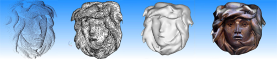
Fig. 2. Stages in the construction of the model of the Head of Medusa by Giacomo Manzù © Serena Artese, 2011. Reproduced with kind permission.
The source data available for the
realisation of the city model were the Regional Technical Maps along
with the orthophoto. The photographs of the façades of all buildings
along the route were taken.
The building of the model of the city involved several steps:
- Extrusion of the buildings from the map to obtain volumes;
- Creation of the Digital Terrain Model;
- Cutting volumes using the DTM;
- Building of the roofs;
- Texturing (rectifying and cropping the original images of building fronts).
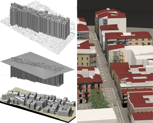
Fig. 3. Steps in the modelling of Cosenza and the view of the city computer model © Serena Artese. Reproduced with kind permission.
A different arrangement of the statues, based on grouping
by artist, was simulated. A version of the open-air museum accessible to the blind
people has been designed, through the inclusion of an additional path consisting of miniature statues and guiding controls (Fig. 4).
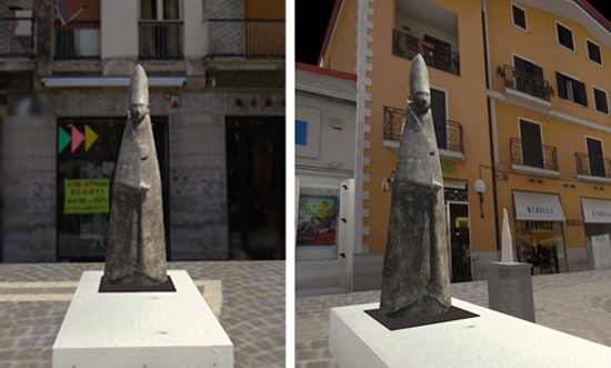
Fig. 4. A computer
model of the Great Cardinal Standing by Giacomo Manzù in the original position (left); the
model of the same sculpture and its miniature in a new
position(right) © Serena Artese. Reproduced with kind permission.
This work is a demonstration of the possibilities offered by city
models and virtual reality to the researches and to the urban planning.
A virtual environment based on a three-dimensional model of
a city, makes it easier to understand the existing situation and
the changes proposed by new projects. Consultation and participation can be extended to all
citizens.
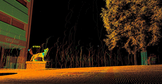
Fig. 5. The data acquisition of the Wolf of Sila, by Mimmo Rotella, and the pedestrian zone with the Scan Station C10 © Serena Artese. Reproduced with kind permission.
Project dates: 2011
Resource status: The visualisation of the MAB Model, both mono and stereo, will be made available on the geomatics website: http://geomatics.unical.it
Contributors: The surveying and 3D models have been realised by Serena Artese M.Sc. and Fiore Manieri, M.Sc. in collaboration with Francesca Principato M.Sc. (surveying). Valerio Di Nardo collaborated on the setup of videos. Thanks to professors Gabrio Celani and Maurizio Muzzupappa for their authoritative suggestions.
Literature and links:
[Author unknown], 'The MAB of Cosenza: The open air museum: "Carlo Bilotti', Arte e cultura da scoprire. La nuova dimensione dell'itinerario, PDF [no date]
G. Artese, V. Achilli and M. Abitrante, Dynamic 3D Representation of Architecture as a Design Tool: The Old Town of Cosenza, The International Archives of the Photogrammetry, Remote Sensing and Spatial Information Sciences, Vol. xxxiv, Part 5/W12, pp. 28–33.
G. Artese, L. De Napoli and S. Artese, T.O.F. Laser Scanner for the Surveying of Statues: A Test on a Real Case, presented at the XXIV International CIPA Symposium, 26 September 2013, Strasbourg, France, International Archives of the Photogrammetry, Remote Sensing and Spatial Information Sciences, Vol. XL-5/W2, 2013. PDF
http://www.mapcosenza.it
http://geomatics.unical.it (forthcoming)
Record compiled by Serena Artese, 17 February 2013. Last updated: 23 November 2013
© Serena Artese, 2013.
Back to the list of 3D projects
|